Submitted by Mel “Butch” Powell, Town of Blooming Grove
Please consider the following points of concern relating to the Final Draft of the Ruekert-Mielke Northeast Neighborhood Plan.
Introduction
The Swan Creek Resource Area, designated by the City of Fitchburg as the Northeast Neighborhood, is a system of distinctive natural, social, and cultural features. Likewise, the proposed Neighborhood Plan is a system of components that involve “natural” (storm water management and residential water delivery), social, and cultural features.
In considering the RM plan, one must keep in mind that the proposed system is radically different from the current system and the RM plan would be imposed on the area in a relatively short period of time. Hence, the current functional balance between human and ecological components would be severely impacted and replaced by a new and unpredictable relationship of human-to-earth.
Thus, any new plan for land use in the Swan Creek Resource Areas should include as a primary consideration, the impact on the plan to the functional aspects of the current land use of the Area.
It is imperative to recognize that the functional aspects of the Swan Creek Resource Area extend beyond the City of Fitchburg’s political boundaries and potentially adversely effect nearby State and County parks, sensitive wetlands which are already impacted by municipal well pumping (Nine-Springs E-Way), property along the shores of Lake Waubesa, and the extensive preserved lands in the Town of Dunn.
1. Environmental Impact
The plan makes little mention of the importance of Swan Creek to the Waubesa Wetlands and the Lake, although it does recognize it as a significant natural feature.
The plan emphasizes the E-Way and Nine Springs Creek is in need of protection, however it does not recognize that Nine Springs Creek is classified as impacted while Swan Creek is classed as less effect by development, at this point in time. Hence, more attention should be given to the sensitive nature and significance of Swan Creek.
The RM plan indicates that development in the plan’s region of analysis would most likely need additional municipal well ( s) to service the area. An additional well is indicated as likely to be placed on West Clayton Road, on the edge of the Nine-Spring E-Way and just outside of the “Northeast Neighborhood” area. No mention is made of the previous degradation of the springs in this area due to municipal pumping. This omission does not sufficiently indicate the impact that development of the scale indicated in the plan will have on the wetlands associated with the E-Way.
There is a significant area of Cluster Residential Housing south of Goodland Park Road and on the rim of the steep banks of Swan Creek. This is, at the very least, reckless. Not only would the construction of cluster homes impact the Creek, but permanent human settlement and its associated activity would severely impact the Creek.
Land is recognized as a resource and not a commodity by the plan (see p 19). This is a positive aspect of the plan because it recognizes the obligation to account for and recognize the environmental service and functionality to the surrounding region entailed in the current land use pattern. The plan does not sufficiently address the consequence to the region of losing this resource if the plan is implemented.
2. Planning Principles underlying the Plan and Map
This plan places the existing land use plan (1995) and the FUDA study of 2003 (Appendix H of the 1995 plan) as the basic conceptual justification for developing the area. See page 4: it portrays this plan as being a contiguous extension of an existing development plan—Green Tech, which is not actually existent.
Note that two other FUDA’s were also identified in the FUDA study. The implementation of the plan should recognize the relative merits of implementing this plan, in this FUDA as compared to the other designated FUDA areas.
This plan under-represents the planning principles that the Committee of the Whole set out during their Nov. 15, 2006 meeting which were designed to give guidance to the Plan Commission in their consideration of future land use in the Swan Creek Resource Area.
The RM plan under-represents the extensive revision of the 1995 Plan as the mandated Comprehensive Plan is created. It appears to justify intensive urbanization of a sensitive area by reference to an out-dated plan that is under revision. These mandated revisions, to be done encompassing Smart Growth principles, testify to the recognition that current and projected economic conditions, resource scarcity, and the need to promote sustainable community development, all make land use policy based on the old 1995 Plan highly likely not to be in the community’s best interests.
High density and medium density housing are positioned so as to minimize the impact on Larsen Road, but the Nora Lane extension (to give the citizens of the Town of Dunn access to the “exciting places” to be created in the Mixed Use area) and the Meadowveiw Road extension contradict the efforts to buffer the border with the Town of Dunn.
3. Socio-cultural and Economic impact
The plan seems to over-estimate the market demand created by the non-existent Green Tech Village. It fails to specify what type of economic activities would support the residential areas. The term “Employment Hub” is too vague to be helpful in assessing the viability of the plan as a blueprint for a functional neighborhood.
The plan makes little mention of affordable housing accommodation except what is implied in the high-density area.
The study recognizes that there will be significant impact on the Oregon School district, yet does not indicate how this impact will be addressed by the Oregon School district. Hence, a major stakeholder in the plan is left unrepresented.
The plan seems to eradicate agriculture from the entire area and replace the economic activities with something like Hatchery Hill and a vague “employment hub.” No discussion in the plan is given to the relative merits/demerits of not retaining more of the working farmland or the possible advantage to Fitchburg’s economy to supporting small scale, sustainable agricultural production of fresh produce for local markets.
Over-all pattern does put new residents in close proximity to parks/possible garden areas and seems to create the potential for walkable neighborhood, however, the area is not really tied to any realistic economic development other than its proximity to Green Tech. There are significant barriers to pedestrian and bicycles transportation between the Green Tech area and the Northeast Area. An opportunity to truly erode the dependency on individual automobile travel is lost by not mitigating this barrier to non-auto travel.
4. Transportation
The plan is contingent on the new interchange, a significant impediment
The plan mentions the possibility of integrating the area with extended bus service, bicycle paths, and regional rail as an option for decreasing auto travel, yet seems to be based on the assumption that auto commuting will continue to be the norm. Bus stops and passage through the US HWY 14 barrier to east/west travel are missing from this plan.
5. Sewers
The plan admits the need for approval with Madison Metropolitan Sewer District to see if they can/are willing to accommodate the new flowage. It seems that little or no consultation has been done on this. This, like the lack of information on impact to the Oregon School District, leaves input from a major stakeholder out of the plan.
skip to main |
skip to sidebar
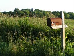
Photo by Nadia Olker
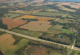
Looking East Toward Lake Waubesa

It takes a team to build a city. Join us in discussing important events and decisions that will shape Fitchburg, Wisconsin and the surrounding area. Help us discover opportunities for vital citizen input. We are the people we've been waiting for.
Welcome!
Fitchbloggers Unite!
Wow, it's been quite a while between posts! But, there's plenty of new material now, so enjoy. :)
To add your own comments on any blog entry, you must first create a free Google Account (using your existing email is fine).
Terry Carpenter
Wow, it's been quite a while between posts! But, there's plenty of new material now, so enjoy. :)
To add your own comments on any blog entry, you must first create a free Google Account (using your existing email is fine).
Terry Carpenter
Categories
- ATC (1)
- Blogs (1)
- Books (3)
- Cal DeWitt (11)
- Carbon Emissions (4)
- CARPC (3)
- Community Gardens (3)
- Comprehensive Plan (2)
- Council Meetings (7)
- Flowchart ;-) (1)
- Green Ideas (1)
- Green Tech Village (1)
- Growth (4)
- Housing Market (4)
- Humor (1)
- Hydric Soils (2)
- Ken Bradbury (2)
- Letters to Editor (10)
- Local Food (7)
- NE Neighborhood Plan (27)
- Neighborhoods (5)
- NEN (39)
- NEN Stormwater Plan (9)
- Oregon (1)
- Phil Lewis (3)
- Plan Comm Meetings (22)
- Poetry (2)
- Politics (1)
- Public Health (1)
- Public Hearings (7)
- Region (2)
- Regional Design (1)
- Ruekert-Mielke (9)
- Sustainability (11)
- Taxes (1)
- Transportation (5)
- Water Resources (11)
- Watershed (1)
- Websites (3)
- Wetlands (2)
Our Rural Character
Photo by Nadia Olker
Links
- Citizens for Responsible Energy
- City of Fitchburg, WI
- Fitchburg's Current Planning Projects
- Fitchburg Fields
- Heathy Future for Kids (Blog)
- Madison Peak Oil (Blog)
- NEN Public Meeting Presentation
- NEN Draft Land Use Map
- NEN Conceptual Stormwater Plan
- Southdale Rimrock Neighborhood
- West Waubesa Preservation Coalition
8/7/07 Public Hearing Links
NE "Neighborhood" Today
Looking East Toward Lake Waubesa
Blog Archive
-
▼
2007
(40)
-
▼
July
(10)
- Take the Local Produce Pledge
- Determine True Costs of Development
- Whose Agenda Is It?
- Professor DeWitt Critiques NEN Stormwater Plan
- Stormwater Management Must Exceed City Standards
- Why Flood Housing Market, Destroy Farmland & More?
- Out-Dated Plan Not in Community's Best Interest
- Too Many Unknowns in NEN Plan
- NE Neighborhood "Plan" is Flawed
- Conceptual Stormwater Study Insufficient
-
▼
July
(10)
Local Food Pledge
No comments:
Post a Comment