Terry's Carpenter' testimony from Aug. 7th Public Hearing:
I would like to see a 50 year or permanent growth boundary and I believe that this process is not a prediction, as some have said, but an effort to shape the future. I want to pick up on Samuel’s comments. On page 138 of his presentation, Phil Lewis provides examples of his Diverse Density design (see below). This graphic shows high density, mixed-use development right along the rail line. Just below that, is the transition to Moderate density as you get farther away. Farming would be adjacent to the Moderate density area and then lastly, Nature. On the graphic for page 137 (see below), Mr Lewis shows how this would work, from Greentech Village to the points east, including the NE Neighborhood. You can see the existing rail line running N and S parallel to Syene Rd and the existing E-Way, shown in green, creating a buffer of open space north of this entire area extending all the way from Fish Hatchery Rd on the left to Lussier Heritage Center on the right. There is also a large area of greenspace around Lacy Road at the bottom of the highlighted rectangle that represents Watershed Protection for Swan Creek.
Inside the highlighted rectangle, the leftmost reddish/orange box represents High Density along the rail to about ½ way between the tracks and Hwy 14. Moderate Density is shown as lighter orange and ends at Hwy MM on the east. The yellow area from MM to Larsen Rd shows food production and Fitchburg actually ends there but the map goes on to show the Town of Dunn with a large Natural area extending close to Lake Waubesa. Although Mr Lewis’ vision is being used in the proposed UGB, for example by focusing on the rail corridor, it is being ignored with regard to the NE Neighborhood. His design shows that everything to the east of Highway MM should be Agriculture and therefore excluded from the UGB and I urge you to remove the NE Neighborhood to accomplish this vision.
I think Mr Lewis would agree that more information is needed to see what impact any development in this area would have on the wetlands, streams, lakes and aquifer. So, portions of the NE Neighborhood that are west of Hwy MM should be included for Moderate Density if and only if they can be shown to cause no threat to Lake Waubesa or its ecosystem.
Phasing is extremely important to the promotion of rail for mass transit. So, I also hope that you will not allow leapfrog development to skip over Greentech Village into the NEN.
Another difference between the current UGB and Mr Lewis’ design is that he excludes large portions from the N/S rail corridor for environmental buffers as you saw on the map on page 137. This is important to allow wildlife, wetlands and streams to flourish and I hope you will designate such environmental corridors to connect natural areas and farmland on the east and west sides of the rail line.
I applaud the emphasis on Mass Transit. And rail seems like the best tool for the long term if we want to reduce our carbon emissions and global warming. Although rapid bus transit might be an interum solution.
I also urge you to seek solutions that will not only protect farmland and other resources but will allow farmers to retire gracefully and help new people begin farming in the urban shadow. We need Purchase and/or Transfer of Development Rights and other programs to empower all farmers, including those whose families settled the Town of Fitchburg. We can’t ignore the fact that our decisions pit neighbor against neighbor as farms fall under different economic rules based on changes to the Growth Boundary. We need to protect farms and respect farmers.
I disagree with some who believe that we owe a profit to land speculators. But, I strongly believe that we owe a decent living and retirement to farmers after their decades of Debt, Sweat and Fears. I hope you will take this into consideration. Thank you
skip to main |
skip to sidebar
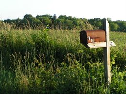
Photo by Nadia Olker
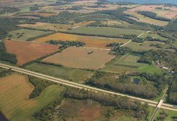
Looking East Toward Lake Waubesa

It takes a team to build a city. Join us in discussing important events and decisions that will shape Fitchburg, Wisconsin and the surrounding area. Help us discover opportunities for vital citizen input. We are the people we've been waiting for.
Welcome!
Fitchbloggers Unite!
Wow, it's been quite a while between posts! But, there's plenty of new material now, so enjoy. :)
To add your own comments on any blog entry, you must first create a free Google Account (using your existing email is fine).
Terry Carpenter
Wow, it's been quite a while between posts! But, there's plenty of new material now, so enjoy. :)
To add your own comments on any blog entry, you must first create a free Google Account (using your existing email is fine).
Terry Carpenter
Categories
- ATC (1)
- Blogs (1)
- Books (3)
- Cal DeWitt (11)
- Carbon Emissions (4)
- CARPC (3)
- Community Gardens (3)
- Comprehensive Plan (2)
- Council Meetings (7)
- Flowchart ;-) (1)
- Green Ideas (1)
- Green Tech Village (1)
- Growth (4)
- Housing Market (4)
- Humor (1)
- Hydric Soils (2)
- Ken Bradbury (2)
- Letters to Editor (10)
- Local Food (7)
- NE Neighborhood Plan (27)
- Neighborhoods (5)
- NEN (39)
- NEN Stormwater Plan (9)
- Oregon (1)
- Phil Lewis (3)
- Plan Comm Meetings (22)
- Poetry (2)
- Politics (1)
- Public Health (1)
- Public Hearings (7)
- Region (2)
- Regional Design (1)
- Ruekert-Mielke (9)
- Sustainability (11)
- Taxes (1)
- Transportation (5)
- Water Resources (11)
- Watershed (1)
- Websites (3)
- Wetlands (2)
Our Rural Character
Photo by Nadia Olker
Links
- Citizens for Responsible Energy
- City of Fitchburg, WI
- Fitchburg's Current Planning Projects
- Fitchburg Fields
- Heathy Future for Kids (Blog)
- Madison Peak Oil (Blog)
- NEN Public Meeting Presentation
- NEN Draft Land Use Map
- NEN Conceptual Stormwater Plan
- Southdale Rimrock Neighborhood
- West Waubesa Preservation Coalition
8/7/07 Public Hearing Links
NE "Neighborhood" Today
Looking East Toward Lake Waubesa
Blog Archive
-
▼
2007
(40)
-
▼
August
(13)
- McIntosh Questions Indulgent Development
- New City Website
- Phil Lewis - Workin' on the Railroad
- Downshift Your Driving
- What If The Experts Are Right?
- Lindsay Questions Water Supply
- WWPC Looks for Win-Win Solutions
- Fitchburg Neighborhood Plan Would Threaten E-way a...
- Pourchot Hopes for Courageous Path
- Shape Future with Phil Lewis' Vision
- Cooke Explains the Depths of Frustration
- Public Hearing Aug 7th - Yes that's tonight!
- Eggleston's Review of "Animal, Vegetable, Miracle"
-
▼
August
(13)
Local Food Pledge
No comments:
Post a Comment