You gotta love that title! On July 26, 2007, I had the pleaure of attending this presentation by retired UW Professor Emeritus, Phil Lewis who just completed his 57th year of focusing on "Regional Design," a study that requires an understanding of how communities in the region fit in harmony with the values and visions of its people. Other first-time and repeat attendees included members of the Fitchburg Planning Commission, city staff and others.

Phil Lewis (Photo by Steve App, State Journal)
Over a few posts, I will share some of what I learned about his regional designs especially for the southern part of Wisconsin including Fitchburg. The City of Fitchburg website has downloadable PDF files (here) containing slides from his Powerpoint presentation some of which I will include in my articles.
Fitchburg and all of Dane County has a tremendous opportunity to take advantage of Professor Lewis’ decades of research and design in our region. And I hope that more people are able to hear his ideas and discuss his visions for the future.
If you want to skip ahead and read about Professor Lewis' ideas for Greentech Village and the Northeast "Neighborhood" in Fitchburg, click here.
Regional Design is crucial to Goals and Visions
From Professor Lewis’ slideshow introduction:
"The use of regional design to reflect and enhance natural, social, and economic resources indigenous to a given region maximizes the existing strengths of that region... Regional design is required to make good comprehensive and transportation plans, and is deeply involved in landuse planning of all kinds... Regional design provides the designation of the proper frameworks, and the organization and methods of interpretation of available data for the development at any scale…
Development issues and the transportation and energy crisis bring regional design to the forefront. We no longer have the luxury of permitting any development scheme to proceed without determining regional goals and visions as well as the forms which they will take.
Although considerable time is required for the actualization of ‘big picture’ plans… their utility and worthiness is clear. They provide a long-term context within which to identify and evaluate short-term opportunities.”
Regional Design should precede Planning
Unfortunately, Regional Design doesn’t always precede Planning as it should. Design concepts begin by identifying all natural and cultural features you want to protect and enhance. They also look for regional patterns and identify 3D concepts for how to build higher, livable densities without destroying critical, life-sustaining systems. This certainly sounds like the right place to start.
Once the Regional Design is complete, Planners use "democratic, social, political, and economic tools" to implement the overall design. As you would expect, for best results, Regional Designers and Planners should work together with feedback between them.
Unguided growth threatens global life support systems
Professor Lewis took us on a whirlwind tour starting with the broad view (the planet) and eventually focusing in on Fitchburg.
This shouldn’t be news to you, but “Unguided Growth Threatens Global Life Support Systems.” In the U.S. alone, the projected net population increase for 2007 is one person every 10 seconds. The world population is expected to double in the next 30 years. It's hard to imagine the huge impact on all of our systems. But, as Mr. Lewis points out, it certainly elevates our responsibility to future generations.
[Side note: One of my favorite tools for explaining growth rates for populations or anything else is a video by retired Professor of Physics, from the University of Colorado, Dr. Albert Bartlett. Do you think 2 or 3% annual growth is insignificant? Click here and choose Video-Stream.]
With increasing population and diminishing cultural and natural resources, what will the future look like? Phil Lewis believes that part of our challenge is to build in harmony with the area’s cultural and natural treasures and to “urbanize sprawl.” Although this sounds like an oxymoron, it means that future growth will be higher in density to lessen the impact on (at least some of) our natural resources.
How could we do this? Build densely around rail corridors.
Dane County’s Rail Network connects to Circle City
The concentration of light, seen in photographs taken from a satellite at night, shows that every one of the cities and villages in Dane County rose up along the old rail network that radiates out from Madison like a nine-armed (or is it legged?) octopus. (See image from page 4 of the presentation.)  Most of the people in Dane County are within a 1-mile walk from a train track, yet we no longer transport people by rail. This offers an opportunity for the county and the region.
As the diagram below (from page 17) shows, we are part of a large Circle City network representing one of the 23 “Urban Constellations” identified in the U.S. These groups were formed by connecting cities, with over 20,000 people, in a way that would have the least impact on the nations resources. Circle City covers a 4-state region and its perimeter includes Chicago, Cedar Rapids, Minneapolis, Green Bay and Milwaukee.
Circle City - Major Cities and Rail Lines (page 17)
 Dane County sits close to the middle of this ring of growth, situated along one rail line that traverses the state from Milwaukee to Prairie Du Chien and others extending from Madison to Janesville or Rockford before connecting to the circle near Chicago. I can't help but think that it must have been fun to create the enormous 3D model of the entire Milwaukee Road line which occupies a fraction of his immense studio. (See photo below from page 72 of the presentation.)
 Approximately 85% of all people in the U.S. live in one of the 23 Urban Constellations. There are 17 million people inside of Circle City constellation, of which, as many as 85% live close to the rail lines. Thus, this large population would be well-served by passenger trains. And not just for commuting but for vacationing as well. For example, one of the scenic, recreational gems inside of the circle is the “Driftless Area,” a vast expanse of unglaciated landscape, in south-western Wisconsin and beyond, that is a valuable but little known natural resource.
The ruggedness of the landscape can be seen in the picture below (from page 21). Imagine getting on a train in Fitchburg and traveling to Lake Michigan or Chicago or perhaps heading toward the Driftless Area and then on to Prairie Du Chien where you board the Delta Queen for a trip to New Orleans (after it recovers). [Pardon the rhyming names... it couldn't be avoided.]
Circle City - 17 Million People (page 21)
 Environmental Corridors
An inventory of natural resources includes water and wetland systems which were crucial to every settlement and steep topography which often meant that timber operations were inhibited making this an area rich with both natural and cultural features. The Driftless Area is a prime example of a huge environmental corridor that should be preserved.
In the 1960s, a major study categorized various landscape features and found that Wisconsin, with its Driftless Area, Northwoods and abundance of lakes and rivers, had 72 different "landscape personalities" compared to only 7 in Illinois. Anyone who has traveled through both states can surely attest to this! In Wisconsin, you need only travel a few miles for a complete change of scenery. In Professor Lewis' studio, you can examine the results of that study represented on a huge map of Wisconsin showing these cherished cultural and physical features. (See picture below from page 41.)
 The Wisconsin Landscape Inventory showed that over 90% of the features, (such as trout streams, caves, hiking trails, farmers' markets, museums and marinas, to name a few), fall within the "environmental corridors" identified. Preserving these corridors is one of the goals of Regional Design.
To be continued in Part 2:
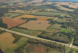
Currently, there is building and expansion on some of the richest farmland in the world all the way from Madison to Rockford. How do various growth strategies compare for resource preservation? And how can we use democratic tools, including education, to help protect our remaining resources as the population grows?

No comments:
Post a Comment